Banklick Creek
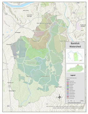
Banklick Creek drains 58 square miles of land in Kenton and Boone Counties. Water from Banklick Creek joins the Licking River and flows northward until it reaches the Ohio River, directly across from Cincinnati. Ultimately, water from the Ohio River ends up in the Mississippi River and finally the Gulf of Mexico.
The Banklick Watershed is a unique mix of rural headwaters and urban downstream areas, with large areas of residential suburban developments throughout. |
What's the Problem?
Water in Banklick Creek has been found to contain pollutants such as bacteria, sediment, oil and nutrients. The Banklick faces the challenges of a suburban watershed, as well as a developed urban watershed. See our How's the Water page for more information.
Banklick Creek has been designated by the Commonwealth of Kentucky as a priority watershed because of long-standing issues with flooding and poor water quality. The Banklick Watershed Council receives funding from the Kentucky Division of Water to improve the water quality within Banklick Creek.
Banklick Creek has been designated by the Commonwealth of Kentucky as a priority watershed because of long-standing issues with flooding and poor water quality. The Banklick Watershed Council receives funding from the Kentucky Division of Water to improve the water quality within Banklick Creek.
Our Approach

The Banklick Watershed Council's goal is to improve and protect Banklick Creek and its many tributaries. Our 2010 Watershed Plan outlined the challenges and proposed solutions.
Over the years, we've learned a lot and continually refined our strategy. Our science-based approach uses recent research on sustainable stream restoration. We focus on:
Learn more about our programs, the latest news, the Banklick Watershed itself, or join us at the next Council meeting.
Over the years, we've learned a lot and continually refined our strategy. Our science-based approach uses recent research on sustainable stream restoration. We focus on:
- Stormwater Runoff - Hydrologic restoration is the philosophy that achieving a more natural flow regime is critical for long-term health of the waterway. In urban areas, paved surfaces prevent rainwater from soaking in and becoming groundwater. Instead, that runoff is put in a pipe and sent directly to a creek. It is too much water, delivered too quickly, and completely overwhelms a creek. This causes creek erosion, pollutants such as total suspended solids (TSS), and flooding in the creek, while also reducing groundwater recharge.
- Pollution Prevention - We help residents understand and fix contamination sources such as failing septic systems or residential lawns (fertilizers or pet waste).
Learn more about our programs, the latest news, the Banklick Watershed itself, or join us at the next Council meeting.
Our Successes
|
Advocacy
125 - Homes with New Sewer Access (Formerly Septic Hot Spot Neighborhoods); a $15 Million investment by SD1 and Kenton County (by 2026) Land Conservation & Restoration (192 acres preserved) Brushy Fork Nature Preserve (2019) Wolsing Woods Wetland (2018-2020) Doe Run Lake Expansion & Trails (2008, 2020) Brushy Fork Creek (Phase I in 2014) Petty Property (2013) Wolsing Trails (2006) |
Pollution and Stormwater Improvements
14 - Failing Septic Systems Repaired 19 - Stormwater Detention Basins Retrofitted Ag Assistance Diary Manure Pond at family-owned Ed-Mar Dairy Community Engagement Watershed Work Parties Tree & Native Wildflower Plantings Creek Cleanups Hiking Trails and Pedestrian Bridge Education, Outreach and Clean Water Advocacy |
For environmental emergencies such as spills of gas, oil or other substances, contact the Kentucky Dept. for Environmental Protection's
Environmental Response Team at 502-564-2380 or 1-800-928-2380
Environmental Response Team at 502-564-2380 or 1-800-928-2380


